Coordinate System
The coordinate system used in the simulator is based on the Algoryx NED (North, East, Down) system.
The Algoryx NED navigation system is designed to provide precise and reliable positioning and orientation information for simulation and visualization applications. Utilizing the North-East-Down (NED) coordinate convention, it enables users to interpret spatial data in a way that aligns with common aerospace and robotics standards. This system facilitates accurate movement tracking, path planning, and integration with other geospatial tools, making it an essential component for scenarios that require robust navigation and situational awareness within the Algoryx simulation environment.
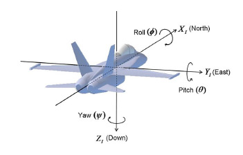
Roll, Pitch, Yaw are used for orientation.